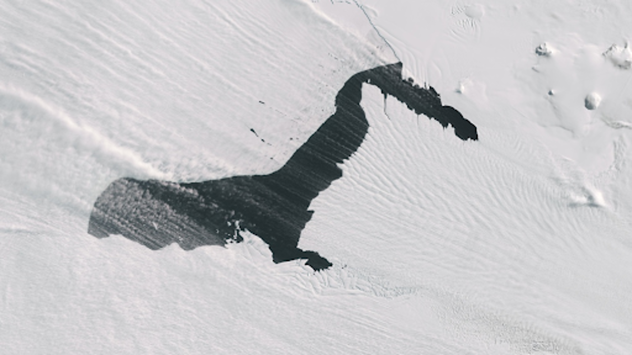
On October 10, steam fog, commonly called sea smoke, was visible alongside swirling bands of white snow above the waters of Pine Island Glacier in Antarctica. (NASA)
A remarkable sight from a NASA satellite reveals a significant glacier in western Antarctica appearing to emit “smoke.” However, what looks like smoke is actually fog, or “sea smoke,” which forms as Pine Island Glacier meets the ocean. This captivating phenomenon was captured earlier this month, showcasing white, cottony wisps floating above the dark water.
Sea smoke isn’t a rare occurrence; it often forms when cold, dry air passes over warmer water. In this case, the conditions arose when strong winds stirred the area, displacing ice and allowing warmer ocean water to rise. As the warmer water came into contact with the colder, dry air, the moisture in the air condensed, creating the fog that gives the appearance of smoke. The scene might remind one of a fog machine in a haunted house, where a ghostly mist envelops the water's surface.
While sea smoke is common in various locations, including the Great Lakes during the first winter blasts, its appearance over Pine Island Glacier is unusual due to the region typically being covered by clouds. The NASA satellite images captured this rare moment, providing a unique view of the glacier.
Pine Island Glacier is a crucial part of Antarctica, closely monitored by scientists because it plays a key role in the ice flow dynamics of the continent. The glacier acts like plumbing for the massive ice sheet it supports, allowing ice to flow into the ocean. However, the glacier faces significant threats from climate change. Over the past few decades, Pine Island Glacier has been losing ice at an alarming rate, primarily due to warmer air and water temperatures, along with a decline in snowfall. This loss has increased dramatically since the 1990s, disrupting the balance of the glacier and hindering its ability to replenish its ice.
Strong winds create distinct lines of snow across Pine Island Glacier. NASA
The glacier, along with its neighbour, the “Doomsday Glacier” known as Thwaites Glacier, is losing ice more rapidly than ever before. Together, these glaciers hold the potential to raise global sea levels significantly. Scientists warn that if both glaciers were to collapse entirely, it could contribute several feet to sea level rise. Furthermore, they help stabilize the rest of the Antarctic ice sheet, which contains enough ice to potentially raise sea levels by an alarming ten feet if it were to fail.
The implications of these changes are critical not only for coastal communities worldwide but also for the global climate system. As temperatures rise, understanding the behaviour of these glaciers becomes increasingly important. The satellite imagery provides valuable insights into how climate change is affecting Antarctica, emphasizing the urgency to address global warming and its impact on these vital ice formations.
In summary, the stunning satellite images of Pine Island Glacier showcase fog formation due to the interaction of warm water and cold air. This glacier is essential for regulating ice flow in Antarctica and is threatened by climate change. As it loses ice at an alarming rate, the potential for significant sea level rise raises concerns for the future of coastal communities worldwide.


