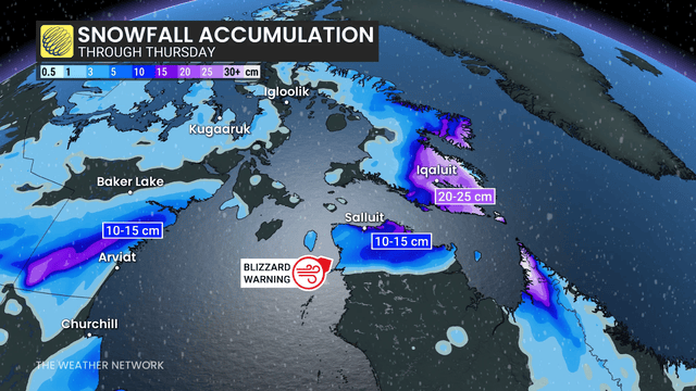
Snowfall warnings are in place for Iqaluit, Nunavut, where 15 to 25 cm of snow is expected by Thursday. The Weather Network
As May long weekend nears, parts of northern Canada face a tough surprise — a strong snowstorm and blizzard warnings. Despite it being late spring, winter weather is making a comeback in these regions.
Blizzard Warning in Northern Quebec and Baffin Island
This month marks the third blizzard warning for Canada’s north. Meteorologist Rachel Modestino says, “We have a deepening low pressure system moving through the Hudson Strait. As the storm intensifies, strong winds are expected to impact northern Quebec and Baffin Island.” These areas lie on the cold north side of the storm, where heavy snow is expected to fall.
Officials have issued blizzard warnings for Kangiqsujuaq and Raglan Lake in northern Quebec. They advise people to avoid staying outside for long periods. The weather agency warns, “Visibility will be suddenly reduced to near zero at times in heavy snow and blowing snow.”
Snowfall and Wind Conditions
By Wednesday evening, the snowfall will ease, but strong winds will stick around, making visibility very low until Thursday evening. According to Environment and Climate Change Canada (ECCC), a blizzard warning means blowing snow with visibility under 400 metres for six hours or more.
Snowfall warnings also cover Iqaluit, Nunavut, where 15 to 25 cm of snow may fall through Thursday.
Rare but Not Unheard Of
Blizzard warnings this late in the season are unusual but not unheard of. For example, in 2022, the Dempster Highway saw a blizzard warning issued as late as June 7-8.
This spring’s snowstorms remind us that winter still holds some power, even as summer approaches. People in northern Canada should prepare for difficult travel and limited outdoor activities due to harsh weather conditions.