El Niño is rapidly re-emerging, with indications that it could be a strong or even very strong event by the end of summer. Image: NOAA
After several months of quiet in the Pacific, the La Niña event that had dominated since mid-2025 is coming to a swift end. This change marks the beginning of something much more concerning—El Niño. Experts are warning that this upcoming El Niño event could be one of the strongest in recent history, and the signs are already starting to appear.
The Return of El Niño
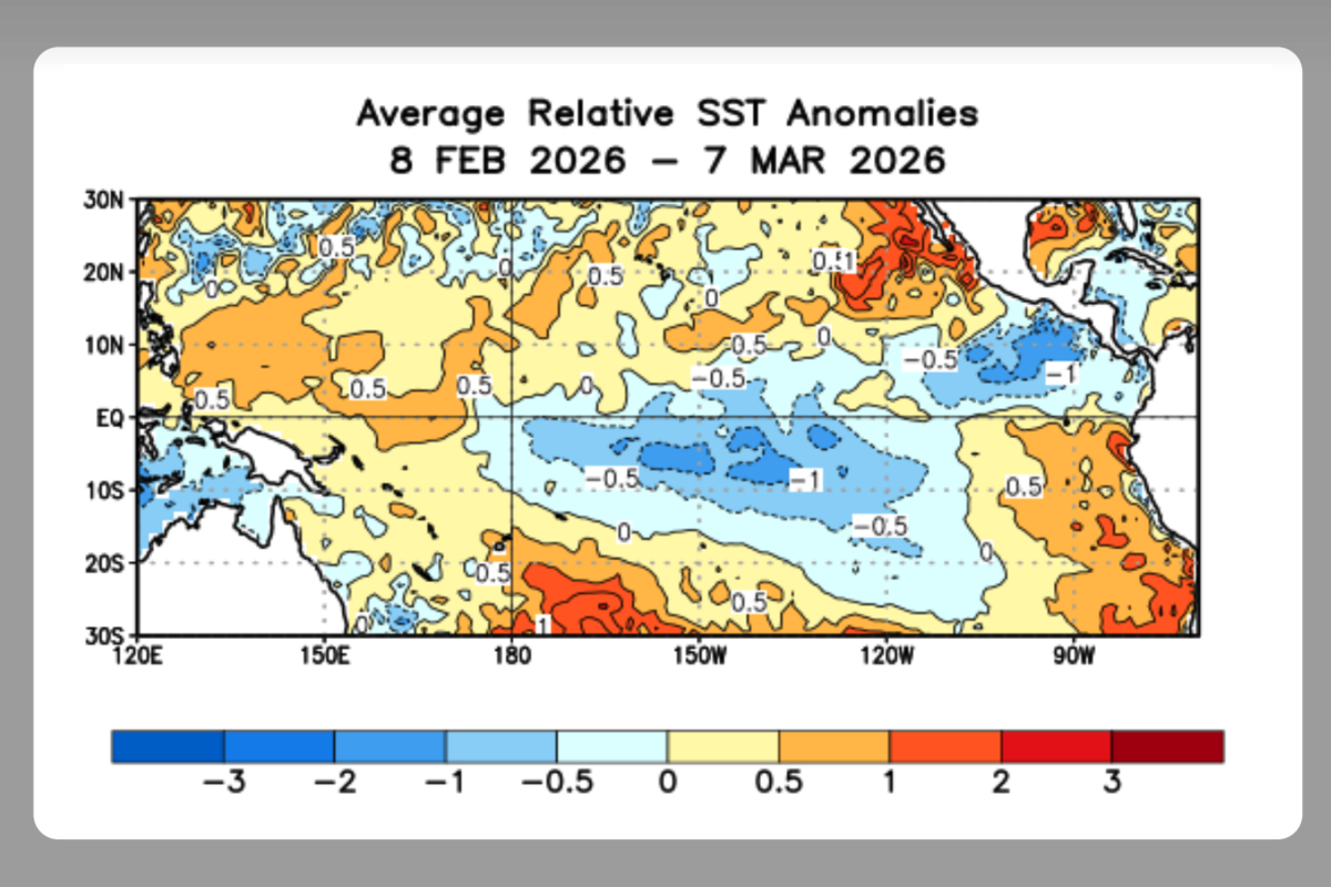
Since mid-2025, the Pacific has been under the influence of a weak La Niña, which brings cooler than usual ocean temperatures. This has kept the global climate in a kind of stasis. However, that is about to change as El Niño re-emerges. As of now, the warming signals in the eastern Pacific are growing stronger, and the leading seasonal models predict with remarkable confidence that El Niño is on its way, possibly arriving with a bang.
What is El Niño?
El Niño is part of a climate phenomenon known as the El Niño-Southern Oscillation (ENSO). This natural cycle, though irregular, has a massive impact on global weather patterns. During an El Niño phase, the lack of trade winds causes the Pacific Ocean’s surface temperature to rise significantly. This warming has far-reaching effects, disrupting weather systems worldwide and causing thermometers to soar in many regions. According to AEMET, El Niño can bring dry conditions to some areas and heavy rainfall to others, leading to significant droughts and floods across the globe.
Rapid Changes Point to Intensity
What’s even more alarming is the speed at which the situation has evolved. Just one week ago, the probability of a neutral climate pattern was 60-70%. Now, there is an 80% chance of a strong or very strong El Niño forming before summer ends. The ocean’s temperature is rising rapidly, a key indicator that things are changing fast.
Experts from NOAA have noted significant subsurface warming in the Pacific, which is the first clear sign of an impending shift. Since the beginning of this year, warm waters from the western Pacific have been moving eastward, and changes in wind patterns are also being observed. These rapid changes resemble the conditions leading up to the 1997-1998 super El Niño, one of the strongest events on record.
Why Experts Are Worried
The concern among experts is growing due to the similarities with the 1997-98 event, which caused widespread devastation. The super El Niño of that year led to extreme weather patterns around the world, including droughts, floods, and significant economic damage. It is estimated that this event caused a $5.7 trillion loss in global economic growth. The worry is that a similar event this year could trigger similar, if not worse, consequences.
A Global Threat
As El Niño strengthens, it could pose serious risks, especially for food production in the Southern Hemisphere during the latter part of the year. With a potential global food crisis already on the horizon, experts fear that the impact of a strong El Niño could exacerbate the situation. While there are still many unknowns, the swift development of this climate phenomenon demands immediate attention. The last thing the world needs now is another devastating global weather event.
El Niño is making a rapid return, with experts predicting a strong or very strong event by the end of summer. The changes in ocean temperatures and wind patterns suggest that we may be in for a repeat of the devastating 1997-98 super El Niño. This poses a significant threat to global weather systems, particularly food production in the Southern Hemisphere. The world must stay alert and prepared for what’s to come.