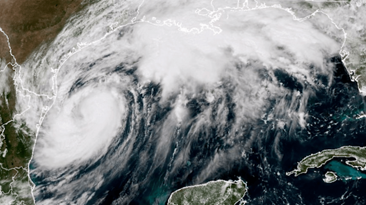
A satellite image from the GOES-16, taken at 2:21 p.m. EDT on September 10, 2024, shows Tropical Storm Francine over the Gulf of Mexico. AP Photo
On Tuesday evening, Hurricane Francine intensified as it moved towards southern Louisiana, becoming a Category 1 hurricane with winds reaching 75 miles per hour (120 kilometres per hour). The storm has gained strength over the unusually warm waters of the Gulf of Mexico, and residents in its path are urgently preparing for its arrival.
Louisiana Governor Jeff Landry urged residents to use the remaining 24 hours to make final storm preparations, emphasizing the need to secure homes and gather necessary supplies. As Francine neared landfall, people were busy filling sandbags, buying gasoline, and stocking up on essentials.
By late Tuesday, the storm was about 350 miles (560 kilometres) southwest of Morgan City, Louisiana, moving northeast at 10 miles per hour (17 kilometres per hour). Forecasters predict Francine will make landfall on Wednesday afternoon or evening. There is concern that the storm could intensify to Category 2 status, with winds reaching up to 110 miles per hour (175 kilometres per hour), potentially bringing a dangerous storm surge and severe winds.
In preparation, residents like Roxanne Riley from New Orleans have been gathering supplies and planning to stay with relatives in safer areas. Riley, frustrated by the recurring storms, is ready to evacuate if necessary. “It’s very frustrating every time a storm comes in,” she said, noting her plan to stay vigilant and keep her car ready.
The National Hurricane Center has issued a hurricane warning for the Louisiana coast from Cameron to Grand Isle, which is about 50 miles (80 kilometres) south of New Orleans. A storm surge warning extends from the Mississippi-Alabama border to the Alabama-Florida border, indicating a risk of life-threatening flooding.
The storm’s intensification is attributed to the Gulf’s exceptionally warm waters, which are currently around 87 degrees Fahrenheit (31 degrees Celsius). According to Brian McNoldy, a senior research associate, the ocean heat content in the Gulf is the highest on record for this time of year.
On Tuesday, September 10, 2024, residents in New Orleans filled sandbags at a local parking lot to prepare their homes for Tropical Storm Francine. AP Photo
In New Orleans, residents have been active in preparing for the storm. Volunteers have distributed thousands of sandbags to help protect homes from flooding. Erika Mann, CEO of a local YMCA, praised the community’s response, saying, “It’s a beautiful effort to do what we do in New Orleans. We’re resilient and we come together to help in the times we need each other.”
Wayne Grant, a relatively new resident, was among those collecting sandbags for his apartment, which had previously flooded. “It was like a kick in the face,” Grant said, reflecting on the challenges of preparing for his first hurricane in the city.
Coy Verdin, who recently rebuilt his home after Hurricane Ida, is also preparing for Francine. Verdin, who has rebuilt his house from scratch, is planning to stay with his daughter in Thibodaux, about a 50-minute drive away, to stay close to home.
The Louisiana National Guard has been mobilized to assist in storm preparations and response. They are equipped with high-water vehicles, boats, and helicopters for potential search-and-rescue operations.
Francine, the sixth named storm of the Atlantic hurricane season, poses significant risks, including life-threatening storm surge and hurricane-force winds. Forecasts suggest heavy rainfall of 4 to 8 inches (10 to 20 centimetres), with some areas possibly receiving up to 12 inches (30 centimetres), leading to flash flooding.
The storm is expected to make landfall between Sabine Pass on the Texas-Louisiana border and Morgan City, Louisiana. The impact of Francine on the already storm-damaged Louisiana coastline could be severe, potentially reaching up to 10 feet (3 meters) of storm surge.


