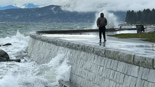
Powerful waves slammed into the Vancouver seawall on November 13, 2025, as rough coastal conditions stirred the shoreline. CTV
Residents along British Columbia’s South Coast face an increased risk of flooding this weekend as high tides combine with an incoming storm system. Weather forecasters warn that the mix of natural tidal patterns and rising ocean levels could push seawater onto roads, beaches, and low-lying areas.
According to Environment and Climate Change Canada, several coastal regions could see minor to moderate flooding. Areas at risk include Metro Vancouver, parts of Vancouver Island, and the Gulf Islands, where shorelines remain especially vulnerable during periods of extreme tides.
Why Water Levels Are Rising
The South Coast has entered a period of very high astronomical tides. These tides occur when the Earth moves closer to the sun, a point known as perihelion. During this time, the sun’s stronger pull adds to the moon’s influence, raising normal tide levels.
This natural rise now lines up with a low-pressure weather system moving toward the coast. Forecasters say falling air pressure allows the ocean surface to lift slightly, adding even more height to already high tides.
“This falling atmospheric pressure will help further elevate coastal water levels beyond predicted tides, thus increasing the risk of coastal flooding,” the agency said in a statement released Friday.
Communities That Could Feel the Impact
Several populated areas sit directly in the path of the expected higher water levels. Vancouver, West Vancouver, South Surrey, White Rock, and Victoria all appear on the list of places that could see flooding if conditions worsen.
Low-lying neighbourhoods, waterfront walkways, and areas near seawalls face the greatest risk. Flooding in these locations often happens quickly and can affect streets, parks, and properties close to the shore.
Forecasters urge residents in coastal communities to remain alert, especially during high tide periods.
Sunday Poses the Greatest Risk
Weather officials expect the highest chance of flooding on Sunday. By then, tides will reach their peak while the storm system moves closest to the region.
Still, uncertainty remains. Forecasters say the exact path and timing of the low-pressure system could change. Even a small shift may affect how much water reaches the coast and which areas see the strongest impacts.
Because of this uncertainty, officials advise people living near the shoreline to prepare for possible changes with little notice.
Debris Could Wash Ashore
Beyond rising water, forecasters warn that waves and flooding could push debris onto beaches and coastal paths. Items such as driftwood, rocks, and other loose materials may wash ashore or move into areas normally dry.
This debris can damage property, block walkways, and create safety risks for pedestrians. Coastal residents and visitors should avoid walking near the water during peak tide times and watch for changing conditions.
What Residents Can Do Now
Emergency officials encourage people in at-risk areas to take simple steps to stay safe. Moving vehicles away from waterfront streets, securing loose items, and staying informed through weather updates can help reduce damage and risk.
Those who live in flood-prone areas should also check drainage systems near their homes and ensure pathways for water remain clear.
A Familiar Pattern With Growing Impact
High tides and storm surges occur regularly along the B.C. coast, but rising sea levels and changing weather patterns increase their impact. Events like this weekend’s remind residents how quickly conditions can change when natural forces combine.
Forecasters will continue to monitor the system and provide updates as new information becomes available. Until then, coastal communities remain on alert as the South Coast moves through another period of elevated flood risk.