Weather officials warn that a strong storm will bring dangerous winter conditions to much of Saskatchewan on Wednesday as it moves across the province. CBC
A strong winter storm will strike Saskatchewan early Wednesday. Forecasters expect blizzard conditions across much of the province. High winds and heavy snow will reduce visibility. Travel may become dangerous very quickly.
“It's going to be a pretty impactful storm. I would say stay home if you can,” said meteorologist Keane Kokolsky.
The storm will begin Wednesday morning. Winds will strengthen between 9 a.m. and noon. Conditions will worsen as the system moves east.
Heaviest Snow Expected in Central Areas
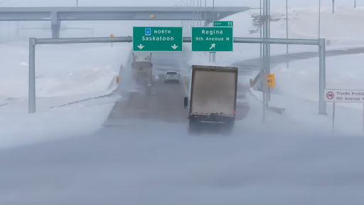
The worst conditions will hit central Saskatchewan. The area stretches from Kindersley to Yorkton. It includes Outlook and areas north of Regina. Forecasters expect the strongest winds and heaviest snow there.
Weather officials issued alerts across most of the province. Yellow and orange alerts took effect Tuesday. Yellow alerts warn of possible power outages. Orange alerts signal severe weather with major disruption risks.
Large parts of southern and central Saskatchewan now face orange alerts. These areas include Saskatoon, Regina, and Moose Jaw. Blizzard conditions remain likely.
Snowfall Could Reach 25 Centimetres
Up to 25 centimetres of snow may fall in southern regions. Snow will begin Wednesday morning. The storm comes from Alberta as a fast-moving weather system.
Kokolsky called the system one of the strongest this season. Alberta clippers move quickly and bring sudden impacts. This one will cross the south-central Prairies.
Strong winds will add to the danger. Gusts could reach 100 kilometres per hour by afternoon. Freezing rain also remains possible in some areas.
Highways Face Dangerous Conditions
Major highways will face serious impacts. The Trans-Canada Highway corridor will see poor conditions. Areas north of it will also feel effects. The Yellowhead Highway corridor will face similar risks.
“There’s going to be very low visibility for travel on the highways,” Kokolsky said.
Drivers should delay trips if possible. Sudden whiteouts may occur. Road conditions could change quickly.
Snow Ends as Arctic Cold Moves In
Snow will ease Wednesday evening and overnight. Colder air will arrive Thursday. Arctic temperatures will follow the storm.
The temperature drop will worsen road conditions. Snow-packed roads may freeze hard. Crews will work to clear main routes.
Saskatoon Issues Travel Warning
Saskatoon expects up to 15 centimetres of snow. Winds may reach 70 kilometres per hour. City officials urged residents to limit travel.
They asked people to leave home only when necessary. Crews will plow roads throughout the day. Officials warned of “rapidly changing road conditions.”
Schools and Services Continue
Saskatoon Public Schools plan normal operations. School buses will run as scheduled. Wheelchair transportation will also operate.
Officials said updates will come if conditions change. Parents should monitor service notices closely.