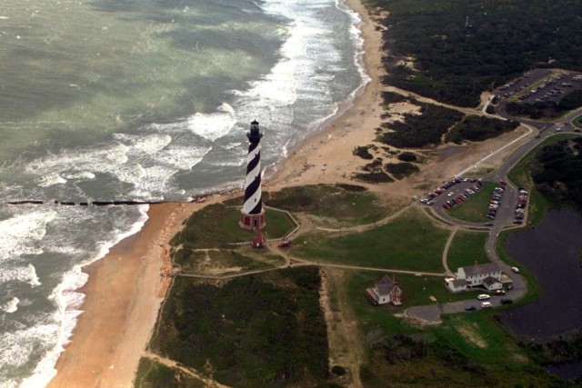
The Cape Hatteras lighthouse stands, Aug 29, 1995 on the Outer Banks of North Carolina.
The Outer Banks of North Carolina face another major test. Hurricane Erin, though far offshore, is sending waves as high as 20 feet. These massive waves threaten the fragile sand dunes protecting the islands and could cut off vital connections to the mainland.
Officials have already ordered mandatory evacuations for Hatteras and Ocracoke islands. The risk is not from direct hurricane winds but from the destruction of NC Highway 12 — the single road linking these barrier islands to the outside world. Once the road washes out, the communities may remain isolated for days or even weeks.
A Way of Life Under Threat
About 3,500 residents of Hatteras and Ocracoke are used to living with isolation. But thousands of tourists visiting the islands are not. For many vacationers, the thought of being stranded is daunting.
Experts warn that the waves are stronger than in recent years. “The vulnerable spots have only weakened over the past five years,” said Reide Corbett, executive director of the Coastal Studies Institute.
What Makes the Outer Banks Unique
The Outer Banks are a chain of barrier islands formed thousands of years ago as glaciers melted. Sand dunes high enough to stay above sea level became narrow strips of land surrounded by water. To the east lies the Atlantic Ocean; to the west, Pamlico Sound.
Northern areas like Nags Head and Kill Devil Hills are heavily developed and not under evacuation orders. The real risk lies further south. Hatteras Island, connected only by NC Highway 12, is highly vulnerable. Beyond it, Ocracoke Island can be reached only by boat or plane.
The Fragile Highway Lifeline
NC Highway 12 is the main artery for the Outer Banks south of Oregon Inlet. On calm days, maintenance crews use plows and sweepers to clear drifting sand. During storms, the ocean and sound often breach dunes, flooding the road with sand and debris. In severe cases, pavement breaks apart or new inlets form, forcing emergency bridges.
The cost of upkeep is staggering. During the 2010s, North Carolina spent over $1 million annually on routine maintenance for NC 12. Another $50 million went into storm repairs. Still, the state continues repairs because Dare County’s tourism brings in nearly $2 billion every year.
Storm damage, however, is unpredictable. Hurricanes Isabel in 2003 and Irene in 2011 cut new inlets into Hatteras Island, forcing residents and tourists to rely on ferries for months. Even smaller storms can close the highway for days.
Rising Seas and Erosion Add Pressure
Beyond hurricanes, rising sea levels are a growing danger. With most of the land just a few feet above sea level, every inch matters. In Rodanthe, one of the most exposed communities, the ocean has swallowed more than a dozen homes since 2020. Officials fear Hurricane Erin’s waves may claim even more houses.
Why Residents Stay
Despite these risks, many residents remain deeply connected to the Outer Banks. For locals, the area’s natural beauty and close-knit community outweigh the constant threats.
Shelli Miller Gates, who first came to the Outer Banks as a college student, described her attachment: “I love the water. I love the wildness of it. It’s the way I want to live my life.”
The Outer Banks lifestyle is even a badge of pride. The abbreviation “OBX” appears everywhere — from bumper stickers to license plates. For many, the risks are simply part of calling this place home.
As Hurricane Erin’s waves pound the dunes, one thing is clear: the battle between nature and the Outer Banks is far from over.