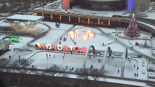
A thin layer of snow covered the skating rink at Nathan Phillips Square in Toronto on Tuesday, Dec. 9, 2025. CP24
Toronto entered the week under a special weather statement as two fast-moving storm systems closed in on the region. Forecasters warned that the pair of systems could drop as much as 10 centimetres of snow by Wednesday. The advisory arrived Tuesday afternoon as the first wave of snow pushed into the city.
Environment Canada said an Alberta Clipper would sweep through overnight and produce snow that may fall heavily at times. The agency cautioned that travel may turn difficult, especially during bursts of blowing snow that reduce visibility. Drivers received a reminder to plan for slow trips and winter conditions.
First System Drops Early Snow
The first storm reached Toronto on Tuesday afternoon. Early snowfall totals for the city sat near three centimetres. Areas across the Greater Toronto Area saw two to five centimetres. Forecasters expected the snow from this system to fade by around 8 p.m., leaving a few light flurries behind.
The brief break will not last long. A second storm is set to arrive overnight and add another three centimetres of snow in Toronto. Together, the two systems could make Wednesday travel challenging from morning through evening.
Heavier Snow Outside the City
Other parts of southern Ontario will feel the storms more intensely. Gusty winds could add some lake enhancement, pushing totals much higher than in Toronto.
Kitchener could receive about 14 centimetres by early Thursday. London could see up to 16 centimetres. North of the city, places like Orillia and Caledon may end up with around 12 centimetres from the back-to-back weather systems.
Forecasters also noted that the second system will carry more moisture. Some parts of the region may see rain by midday Wednesday as temperatures rise. That mix of snow and rain could create slushy conditions in the afternoon. Colder air will return Thursday, which may help freeze any leftover water.
City Prepares for a Busy Night
Toronto’s winter crews plan to begin salting as soon as snow starts sticking to the roads. Sidewalk plowing will begin when two centimetres of snow collects. City officials urged residents to use extra caution Wednesday, as snow may fall during both rush hours.
The city also warned that rain followed by falling temperatures could produce icy patches. The shift back to snow in the evening may create slick streets until crews can resume salting.
What to Expect Next
Temperatures hovered around freezing Tuesday but felt closer to –11 with the wind chill. Wednesday’s high should reach about 2 C as snow changes to rain in parts of the region.
Forecasters expect conditions to return to colder, more winter-like weather by Thursday.