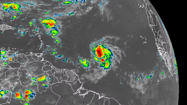
A satellite image shows Tropical Storm Jerry swirling over the central Atlantic Ocean on Tuesday morning. NOAA
A new storm has formed over the central Atlantic Ocean. Tropical Storm Jerry, the 10th named storm of the season, is expected to strengthen into a hurricane by Wednesday, according to forecasters.
As of Tuesday evening, Jerry carried sustained winds of 50 mph and was located more than 1,000 miles east-southeast of the northern Leeward Islands. The storm is moving west-northwest and could pass close to the islands later this week.
Officials have issued tropical storm watches for several islands, including Barbuda, Anguilla, St. Martin, Antigua, St. Kitts, Nevis, Montserrat, Guadeloupe, and St. Barthélemy. These areas could see winds between 39 and 73 mph within the next two days.
Expected Path and Strength
Meteorologists say Jerry will likely track near or north of the Leeward Islands as a Category 1 hurricane later this week. Heavy rain and strong winds are possible depending on the exact path.
The storm is forecast to gain more strength between Friday and Saturday, potentially reaching Category 2 status as it moves east of Bermuda over open waters.
While Jerry is a strong system, experts say it won’t pose a threat to the U.S. mainland. A cold front moving off the East Coast is expected to steer the storm harmlessly out to sea.
Storms Brewing Elsewhere
Forecasters are also keeping a close watch on the Gulf of Mexico and the Caribbean, where late-season storms often form. These regions tend to produce the most dangerous systems in October because they are closer to land.
There’s a small chance a tropical system could develop in the southwest Gulf later this week, but the bigger concern lies in the western Caribbean. A large area of unsettled weather known as the Central American Gyre could form by mid-October.
This weather pattern often gives birth to late-season tropical storms and hurricanes. While it’s too soon to tell if another storm will emerge, meteorologists will be watching the region closely in the coming weeks.
A Busy End to Hurricane Season?
The Atlantic hurricane season typically quiets down in late fall, but history shows that October storms can still be severe. On average, four named storms form between October and November.
Some years end calmly, while others finish with a surge of activity. Last year, seven storms formed during the same period, compared to only two in 2023.
Late-season storms can be devastating. Hurricane Michael (2018) struck Florida as a Category 5 in October. Hurricane Matthew (2016) and Hurricane Sandy (2012) also caused widespread destruction late in the season.
So far in 2025, the Atlantic has produced several powerful hurricanes — Gabrielle, Humberto, and Imelda — in just two weeks, following a quiet start to the year. However, no hurricanes have made landfall in the U.S. so far. If that continues, it would mark the first hurricane-free season for the country in ten years.