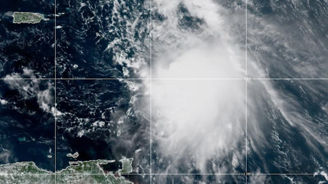
A NOAA satellite image taken at 11:50 a.m. EST on Thursday, October 9, 2025, shows Tropical Storm Jerry. (NOAA)
Tropical Storm Jerry churned through the Atlantic on Thursday, heading toward the Leeward Islands, while Tropical Storms Priscilla and Raymond moved along Mexico’s Pacific coast. Forecasters warned that all three systems could bring heavy rain, flooding, and strong winds across the Americas over the coming days.
Meteorologists said Raymond formed midday Thursday, becoming the third active storm in the Pacific. Meanwhile, a weakening system, post-tropical cyclone Octave, lingered off Mexico’s southern coast.
Raymond was located about 190 kilometres south-southeast of Zihuatanejo, Mexico, with winds reaching 75 km/h. It moved west-northwest at 22 km/h, and forecasters expected it to gain strength before weakening this weekend.
Jerry Nears the Leeward Islands
In the Atlantic, Jerry was about 285 kilometres east-southeast of the northern Leeward Islands, moving west-northwest at 30 km/h with sustained winds of 100 km/h. Forecasters expected the storm to pass near or just northeast of the islands Thursday night and strengthen into a hurricane by late Friday.
A tropical storm warning was in effect for Barbuda, Anguilla, St. Barthelemy, St. Martin, and Sint Maarten. Watches were also issued for Antigua, St. Kitts, Nevis, Montserrat, Saba, St. Eustatius, and Guadeloupe.
Officials in Guadeloupe warned residents to prepare for possible power outages as the island continued to deal with grid problems made worse by bad weather.
U.S. Southeast Faces Coastal Flooding
Along the southeastern U.S. coast, a separate storm system — combined with King Tides from a closer-than-usual moon — could bring flooding and strong winds to parts of North Carolina and South Carolina through the weekend.
In Charleston, forecasters predicted tides as high as 2.6 metres on Friday morning, one of the highest on record in more than a century. City officials offered free parking in garages to help residents move vehicles from low-lying streets.
Along North Carolina’s Outer Banks, authorities warned that Highway 12 on Hatteras and Ocracoke Islands could close due to ocean overwash. Coastal erosion continues to worsen there, with 21 homes lost to rising sea levels and shifting beaches since 2020 — including 10 destroyed in the past month by waves from recent offshore hurricanes.
Pacific Coast on Alert
In the Pacific, Tropical Storm Raymond was expected to remain offshore through Friday before nearing Baja California Sur this weekend. A tropical storm watch was issued from Zihuatanejo to Cabo Corrientes.
Priscilla, once a major hurricane, weakened to a tropical storm with winds near 75 km/h as it moved north-northwest at 13 km/h, about 265 kilometres west-southwest of southern Baja. It is forecast to bring flash flooding to parts of Arizona, California, and Nevada as it moves inland and weakens further.
Meanwhile, Octave, another Pacific storm, dissipated Thursday about 580 kilometres off southern Baja California.
La Niña Returns
Meteorologists said roughly seven weeks remain in the Atlantic hurricane season, but global weather patterns are already shifting. The cooling La Niña phase has returned in the Pacific Ocean, which can intensify hurricanes and cause heavy rain or drought worldwide.
While it may not greatly affect this year’s Atlantic storms, scientists said it could shape global weather in the months ahead.