Canadians can expect changing winter conditions this week as storms sweep through the Prairies, Ontario and Quebec. CTV
Canadians in several provinces are preparing for a week of shifting winter weather as new systems move across the country. Forecasters say this stretch may also mark the start of a colder winter phase as changes form high in the atmosphere.
Heavy snow hits Alberta and Saskatchewan
A quick-moving system brings fresh snow to parts of Alberta and Saskatchewan on Monday. Forecasters say areas near the Cypress Hills, from southeast Alberta into southwest Saskatchewan, will see up to 20 centimetres of snow. Other regions expect between 10 and 15 centimetres. Strong northwest winds will blow snow around and cut visibility to less than 500 metres at times. The snowfall ends by evening, but winds stay strong and temperatures fall. Officials warn drivers to expect sudden shifts in road conditions.
Stronger system forms over Ontario and Quebec
Another system develops this week and brings greater impact to Ontario and Quebec. Rain begins in northeastern Ontario on Tuesday and shifts to snow from west to east by Tuesday night. Areas near Lake Superior could see totals reaching 35 centimetres by Friday, along with poor visibility. Strong northerly winds come with the snow. Environment Canada issued a winter storm watch for parts of Ontario as a result.
Southern Ontario cities such as Toronto, Ottawa and Windsor start the week with rain and easterly winds. Colder air reaches the region overnight Wednesday into Thursday, turning rain to snow. Forecasters say this system stretches across both Ontario and Quebec and will affect communities in both provinces.
Temperatures vary by region. Timmins sees near-freezing conditions early in the week before daytime highs drop to -8 C on Friday and possibly -10 C on Saturday. Toronto may climb to 11 C on Wednesday, but falls to about 1 C by Thursday when snow begins.
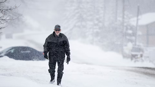
Officials ask people to avoid non-essential travel and use caution on sidewalks and roads. They warn of possible delays and disruptions to transit, services and utilities.
Quebec prepares for heavy snowfall
Parts of Quebec fall under a special weather advisory. Snow may fall at rates of up to two centimetres per hour between Wednesday afternoon and Thursday evening. Significant accumulation is expected during this period.
Colder air expected to continue
Forecasters say the cold snap does not end this week. A strong upper trough forming over Canada drives the jet stream south, letting arctic air move across the country. Signs also point to a stratospheric warming event, which often allows cold air to spread more easily. The pattern mirrors the one that led to the 2014 polar vortex. Forecasters say this week may preview a colder winter ahead.