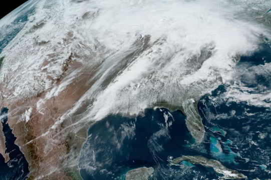
A massive weather system moved across the United States on Wednesday, bringing storms and unsettled conditions. (Photo: NOAA)
Strong, warm winds blowing at 50 mph swept into southwestern Tennessee on Wednesday, knocking out power for thousands. This was just the beginning of a dangerous storm expected to bring heavy rain and severe weather to millions in the Mid-South through Saturday.
At first, everything seemed normal despite warnings from officials about possible tornadoes and flooding. Tourists were still taking pictures on Beale Street, and construction projects continued as if nothing was happening. But the calm wouldn’t last long. The first heavy rains arrived, with occasional sunshine pushing temperatures into the 80s, increasing the chances of strong storms.
Officials and weather experts warned that this storm could be life-threatening. More than 40 million people across multiple states were at risk. Tennessee’s governor declared a state of emergency on Wednesday evening, requesting federal help before the worst of the storm hit. Several tornado and severe thunderstorm warnings were already in place. The National Weather Service in Memphis called it a “generational flooding” event, meaning the kind of flood that happens once in a lifetime.
In Kentucky, the governor also declared a state of emergency. “This is one of the most serious weather threats I’ve seen,” he said, urging people to take precautions.
By Wednesday night, Missouri’s Highway Patrol reported tornado damage in Washington County. Photos showed destroyed vehicles and debris scattered across fields.
From Thursday to Friday, the highest level of rainfall warning was issued for parts of five states. The Weather Prediction Center called it an “extreme flooding scenario” because the storm would last for days. Some areas could face both tornadoes and flooding at the same time.
The National Weather Service in Little Rock warned that the coming flash floods could be catastrophic, affecting places that rarely flood. “Some areas may experience 25-to-100-year flood levels,” they wrote.
A rare “Level 5 out of 5” warning for severe storms was issued, covering six states and over 2.5 million people. Strong tornadoes could travel for miles, causing destruction along the way.
By Sunday, up to three months’ worth of rain could fall in just a few days. The hardest-hit areas could see more than a foot of rain, leading to dangerous river flooding. Roads could become impassable, and water levels could rise quickly.
The storm, which already brought tornadoes and large hail to the Plains, will move eastward, fueling more intense thunderstorms. A plume of tropical moisture will feed the storm, making the rain heavier and more widespread. Cities like Little Rock, Memphis, Nashville, and Louisville—all home to over 7 million people—are at high risk.
Another wave of tropical moisture will hit from Thursday into Friday, increasing the threat for northeastern Arkansas, northwestern Tennessee, southwestern Kentucky, and southeastern Missouri. The risk for flooding will shift westward into Texas, Oklahoma, Missouri, and Illinois by Saturday. Some places could be hit with flooding multiple times over the next few days.
Tornadoes remain a major concern. The Storm Prediction Center warned of a possible tornado outbreak from Wednesday night into Thursday. “Supercell” storms, known for producing violent tornadoes, could form and continue overnight, making them even more dangerous.
In Little Rock, officials reminded residents to have a plan in place. “Pack water, medications, and important documents. Know where to take cover,” they posted online.
More than 40 million people face some level of storm risk. Over 2.5 million are in the highest danger zone, including Memphis and Jonesboro, Arkansas. Some areas facing potential tornadoes are also in flood-prone zones, making the situation even more dangerous.
Besides flooding and storms, winter weather is also causing problems. North Dakota, South Dakota, and Minnesota are under winter storm warnings, with heavy snow and strong winds. More than a foot of snow is expected in some places, along with whiteout conditions and possible power outages.
The Northeast won’t escape the storm either. Northern New York and parts of New England will see a wintry mix, making travel hazardous. Vermont, New Hampshire, and Maine could experience icy roads and dangerous conditions.
With severe storms, tornadoes, flash floods, and snow all happening at once, officials are urging people to stay alert and be prepared.


