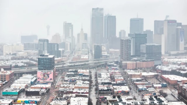
Snow covered Dallas, Texas, on Thursday, bringing winter weather to the area. CNN
A powerful winter storm is sweeping across the South, causing snow, freezing rain, and rain in its path. The storm began on Thursday, affecting the southern Plains and expanding rapidly. As it moves eastward, it threatens to disrupt nearly 1,400 miles of the South, bringing the coldest temperatures of the season. This storm is particularly dangerous for a region that is not accustomed to such severe winter weather.
The wintry weather began early Thursday morning in western and northern Texas and gradually spread into North Texas, Oklahoma, and Arkansas by the afternoon. Meanwhile, heavy rain developed farther south. Several states have declared states of emergency, including Tennessee, Arkansas, Georgia, North Carolina, and multiple counties in Oklahoma and Alabama, as authorities prepare for significant impacts.
In northern Texas and southern Oklahoma, snow accumulated quickly. By the afternoon, areas north of the Dallas-Ft. Worth metroplex and along the southern Oklahoma border had received at least four inches of snow. Oklahoma City also saw one or two inches of snow. The storm created hazardous driving conditions, with reports of jackknifed tractor trailers and cars getting stuck in both northern Texas and southern Oklahoma. A section of Interstate 35 in southern Oklahoma was completely shut down due to a crash, causing massive traffic backups.
The storm also disrupted air travel. By Thursday afternoon, more than 2,000 flights had been canceled, with nearly 40% of those cancellations affecting Dallas-area airports. The Dallas Independent School District, the second-largest in Texas, closed all schools and offices for Thursday and Friday due to the storm. Schools in nearby Plano Independent School District also closed.
In Texas, frigid temperatures are expected to increase power demands, but the state's grid operator, ERCOT, reassured residents that grid conditions are expected to remain normal. This comes after the disastrous winter storm of 2021 that led to power failures and claimed over 200 lives.
As Thursday night approached, the storm's effects continued to expand, reaching the Mississippi Valley. Arkansas's Little Rock School District also canceled classes and offices for Thursday and Friday. Snow, sleet, and freezing rain are expected to create even more treacherous travel conditions, particularly in Arkansas, where ice can cause accidents and power outages. A thin layer of ice, even as little as a tenth of an inch, can turn roads into dangerous, slippery surfaces.
Areas in Texas, Oklahoma, and Arkansas are expected to experience moderate to extreme impacts due to snow and ice, with some places facing major disruptions and dangerous travel conditions. Snow will continue accumulating through Friday, especially in northern Texas, southeast Oklahoma, and parts of Tennessee, with totals reaching up to six inches in certain spots, particularly in central Arkansas.
As the storm tracks further east, it will bring messy winter weather to the rest of the South. Northern Mississippi, northern Alabama, and northern Georgia are expected to see at least three inches of snow, with some areas possibly experiencing an icy mix. Atlanta, which hasn’t seen an inch of snow in nearly seven years, has a small chance of snowfall early Friday, which will quickly transition into sleet and freezing rain, making travel hazardous into the weekend. City government offices will be closed on Friday, and warming centers are being set up for residents.
The storm will continue to affect the Carolinas and other East Coast regions by Friday night. Charlotte, North Carolina, which hasn’t seen measurable snow in nearly two years, is likely to receive its first snowfall this weekend. A second storm, moving south from Canada, will combine with the southern storm to spread precipitation throughout the Midwest and East.
As the storm moves east, it will leave behind gusty winds, especially in the Northeast, and quickly exit the U.S. by Saturday morning.


