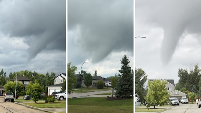
A storm passed through Dugald, Manitoba, on August 6, 2025, bringing rough weather conditions to the area. CTV
A powerful storm moved across parts of Manitoba on Wednesday evening, bringing funnel clouds and large hail. Weather officials received several reports from people who saw funnel clouds and hail the size of golf balls.
The storm formed north of Winnipeg and moved toward Dugald. That’s where most of the funnel cloud sightings happened.
Weather team speaks out
Kean Kokolsky, a weather expert, confirmed the funnel clouds. However, he said no tornado has been confirmed yet.
“We can’t confirm any touchdowns at this time,” Kokolsky said.
He explained that more information is needed to know if a tornado actually touched the ground. “An investigation will have to take place… We’ll have to gather some reports from the eyewitnesses and the public to see if there was any,” he added.
Tornado warnings in many places
Due to the storm, tornado warnings were sent out for many communities. These included Rockwood, St. Andrews, St. Clements, West St. Paul, East St. Paul, and Springfield.
People in these areas were asked to stay alert and take cover if needed.
Hail reported in Stonewall
Kokolsky said there were reports of large hail falling in Stonewall. Some people said the hail was as big as golf balls, which can cause serious damage to homes, vehicles, and crops.
Photos and videos shared on social media showed hail covering the ground and damaging windows.
Storm moving east
As the storm continues to move, Kokolsky said it is expected to leave Manitoba by the evening.
“Into the evening here, as they approach the Ontario border, the severe threat should diminish,” he explained.
The southeast region of Manitoba still has a severe thunderstorm warning in place. Other areas, including Winnipeg, are under a thunderstorm watch.
Officials are closely watching the storm’s path and will keep updating the public.