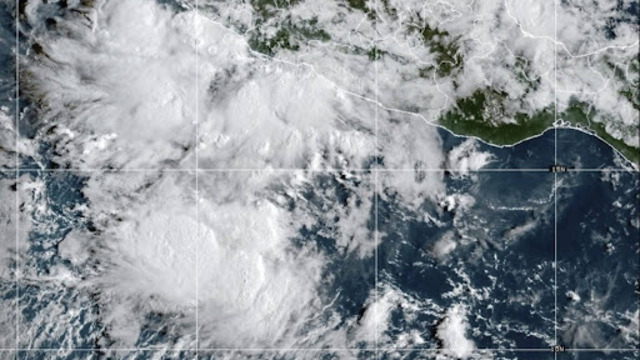
A satellite image from GOES-19, taken Friday, Sept. 12, 2025, at 10:10 a.m. EDT, shows Tropical Storm Mario off Mexico’s Pacific coast. NOAA.
Tropical Storm Mario formed Friday off Mexico’s Pacific coast, officials say. The storm brings strong winds, heavy rain, and the possibility of flash flooding. Forecasters warned that coastal areas should prepare for stormy conditions over the weekend.
“Mini” Storm Packs Power
The National Hurricane Center called Mario a “mini” storm, but it still had sustained winds reaching 40 mph (64 km/h). While smaller than major storms, Mario carries enough strength to cause damage in vulnerable areas.
Areas Under Watch
A tropical storm watch is in place for parts of Michoacan state. The watch stretches from Lázaro Cárdenas to Punta San Telmo. Residents are advised to stay alert and follow local safety instructions.
Storm’s Current Location
Mario was centered about 40 miles (64 kilometres) south-southwest of Zihuatanejo and around 60 miles (97 kilometres) south-southeast of Lázaro Cárdenas. Meteorologists expect the storm to gain strength as it moves along the coast.
Rainfall and Flooding Risk
Officials estimate Mario will drop 2 to 4 inches (5 to 10 centimetres) of rain, with some areas receiving up to 6 inches (15 centimetres). Flash flooding is possible in higher terrain. Coastal states expected to feel windy conditions include Guerrero, Michoacan, and Colima.
Safety and Preparedness
Authorities are urging residents in affected areas to stay informed and take precautions. While Mario is not a major hurricane, even smaller storms can cause damage, especially in low-lying and flood-prone areas.
Looking Ahead
Forecasters continue to monitor Mario closely. The storm’s path and strength could change in the coming days, and updates will be released to keep communities prepared. Residents should follow local advisories and avoid unnecessary travel during heavy rain or high winds.