Crews across London continue clearing damage left by the Boxing Day freezing rain as heavy rainfall triggers a flood warning. At the same time, London Hydro is preparing for possible new problems on Monday as strong winds move through the area. CBC
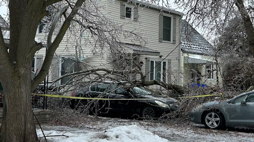
Cleanup crews in London barely caught their breath after the Boxing Day ice storm when another round of rough weather swept through the city on Sunday. Heavy rain and strong winds arrived just as power crews wrapped up repairs from freezing rain that knocked out electricity and brought down trees across the region.
A flood warning now remains in effect as winds continue to gust through Monday. Utility workers and emergency teams say they expect more challenges as the weather system moves through.
Power Crews Stay on Alert
By Sunday morning, most homes that lost electricity during the Boxing Day storm had power restored. Crews worked through thousands of outages after ice-coated tree branches snapped and fell onto power lines and roads.
London Hydro spokesperson Kathryn Arnot said crews stayed ready for more trouble as winds picked up.
“We need to be prepared for that because what we might see is a lot of these frozen tree limbs start to fall off again with high winds,” Arnot said.
Workers reduced outages from more than 70 at the height of the storm to only a handful of individual homes by Sunday. Even so, crews continued responding to hundreds of trouble calls while preparing for new damage.
Strong Winds Expected to Continue
According to Environment Canada, wind gusts could reach up to 80 kilometres per hour. Forecasters said the strongest winds would begin Sunday night and ease by early Tuesday morning.
Officials warned that high winds combined with ice-damaged trees could lead to falling branches, blocked roads, and renewed power interruptions. Residents were urged to secure loose items and avoid parking near large trees.
Flood Warning Issued for Local Waterways
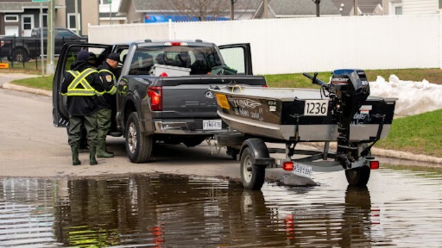
The rain created another concern. The Upper Thames River Conservation Authority issued a flood warning as water levels began to rise in streams, rivers, and drainage ditches.
Rain started Sunday afternoon, with 30 to 60 millimetres expected before clearing early Monday. Since the ground remains frozen and soaked from earlier precipitation, water cannot absorb easily into the soil. Melting snow and ice added to runoff, increasing the risk of flooding.
Thames River Levels Rising
The Thames River continued to rise through Sunday night. Officials expect the river to reach peak levels by Monday evening and stay high for the rest of the week.
Conservation officials urged residents to keep clear of flooded areas.
“Everyone is reminded to stay out of any flooded areas and not drive through flooded roadways,” the authority said. “Parents and caregivers should keep children and pets away from watercourses.”
They also warned that riverbanks may turn slippery and unstable, while ice along the water could break apart without warning.
Residents Urged to Stay Cautious
City officials asked residents to remain alert as cleanup continues and weather conditions change. Crews continue monitoring roads, power lines, and waterways to reduce risks where possible.
With high water and strong winds expected to linger, authorities say caution will remain key in the days ahead.